Well, they’re mostly not actually buoys, but whatever.
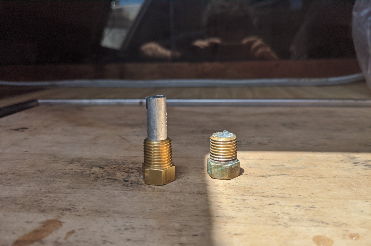
Before we left, I did the other spring maintenance tasks that I forgot to do last time. They were quick ones…replace the air filter and replace the zinc in the heat exchanger. It took me a long time to figure out what a heat exchanger was. I tried to explain it in 2016 like this:
Our engine is freshwater cooled, as opposed to raw water cooled. I find these terms less than descriptive, and have to stop and evaluate them every time I try to use one, but basically a raw water cooled engine sucks up the water that the boat is floating in and circulates that directly through the cooling channels of the engine. A freshwater cooled engine has a closed cooling system full of antifreeze, like a car’s engine, and it sucks up the water that the boat is floating in to cool the antifreeze through a heat exchanger, somewhat analogous to a car’s radiator.
The thing with the heat exchanger is that it has dissimilar metals in it (I don’t even know what…probably copper for its heat conductivity and steel or something for the structural bits) and when you put dissimilar metals in an electrolyte, like saltwater, you’ve made a battery. The mild electrical current that is produced is the ions leaving the “less noble” metal, and eventually, enough leave that the metal falls apart. To prevent this, we introduce an even less noble metal, in this case zinc, and it takes the entire beating. It’s much easier and cheaper to replace the sacrificial anode than the entire heat exchanger.
I guess I need to keep better track of the zinc in mine though, because every time I look at it, it’s gone.
It was warm, and there was the typical sea breeze, making for pretty much ideal sailing conditions: 10 or 12kts from the southeast. We raised the main just outside the creek, fell off onto close reach and unfurled the jib, and took off down the bay.
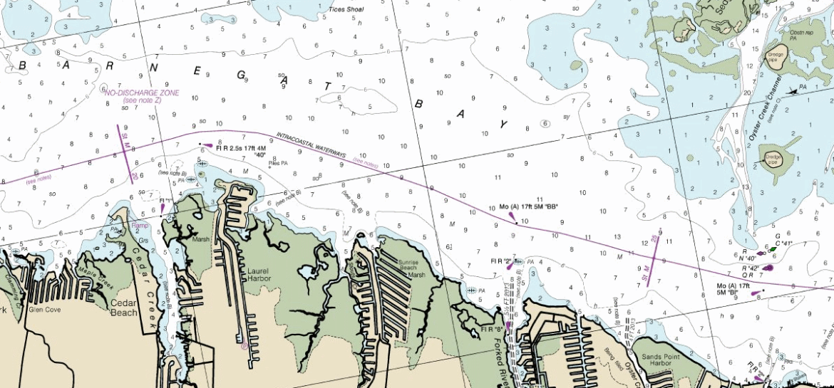
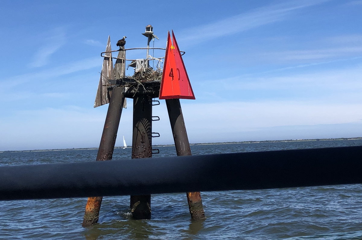
I make reference to certain navigational aids in the bay all the time, but I probably never explain what they are. Most of them are Intracoastal Waterway (ICW) markers, which is an extensive inland waterway that runs basically from Boston, MA to Brownsville, TX (with some notable discontiguous areas, including around New Jersey). From Bayhead (the northernmost point of Barnegat Bay) to Cedar Creek, the numbering almost makes sense. At the very least, it’s a series of integers that generally get larger as the ICW winds south. 40 is perhaps my most mentioned marker, as it’s just to the south of Cedar Creek and basically marks “home” for me. Most of the ICW markers are also homes for osprey, and as we passed 40, I spoke to the ones hanging out there, as I always do. They were initially timid, perhaps dumbfounded by my fluent osprey, but eventually replied as we glided by.
See if you can guess the pattern. The markers from Good Luck Point south are numbered: 36, 37, 38, 39, 40… and, that’s right, BB.
BB comes after 40. I assume this means “Barnegat Bay,” although it’s not really at an entrance to the bay, and is more in the middle? I guess that makes sense? I personally would have gone with 41, or possibly even FR if we were getting fancy, since it essentially marks the entrance to the Forked River (pronounced with two syllables; fork-id).
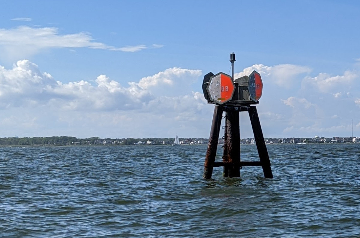
Note that BB is an octagonal shape with red and white coloring. This is a “safe water” or mid-channel marker, which can be passed on either side. It’s more of a “you are here” marker than an indication of where you should go (unlike 40, which is a red triangle, meaning that you should stay to the right of it when going north-ish).
And what comes after BB? Of course, it’s BI. This likely means Barnegat Inlet.
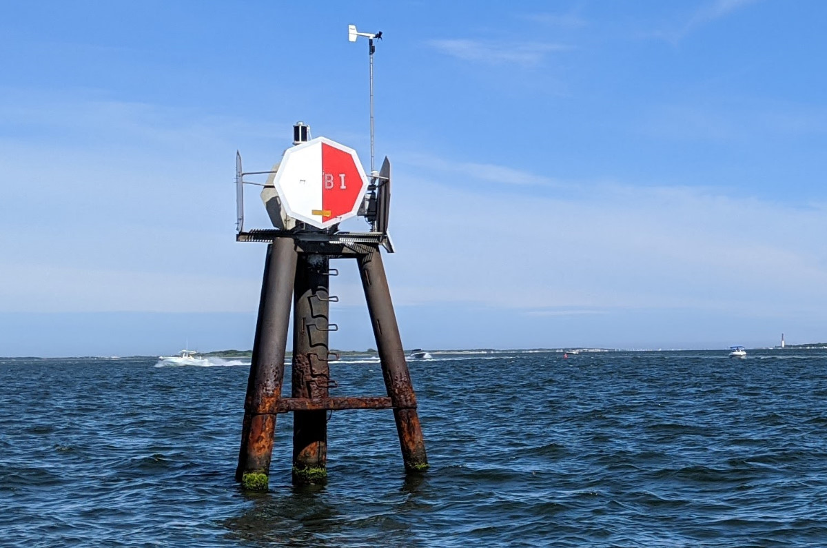
Heading south, if we were to bang a left at BI, we’d be heading down the Oyster Creek channel toward Barnegat Inlet. If these were numbered in order, BI would be called 42, but it isn’t. The Oyster Creek Channel, however, has exactly 42 markers, so there is a 42 is right next to BI, which isn’t confusing at all. At least the Oyster Creek Channel markers are nuns and cans—proper floating buoys—as opposed to the weird three-legged steel daymarks that denote the ICW. BI is also an octagonal mid-channel marker that I guess you could technically pass on either side, but I tend to always stay to the west of it, because it gets shallow quickly to the east if you’re not exactly in the channel going toward the lighthouse.
So, it went 38, 39, 40, BB (not 41), BI (not 42), and what comes next? Obviously, it’s 42. I have no idea. I assume this all made sense at one time, and like a Google Sheet that you’ve shared with too many people, has become a tangled web of modifications, broken formulas, and earnest but incoherent corrections.
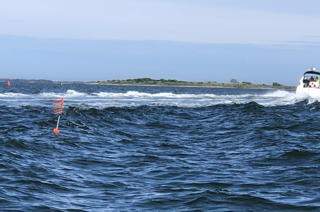
Beyond the peculiarities of the official markers, there are even more creative personal buoys out there. During our sail, we came across a string of crab pots (I assume?) that were marked with tiny little floats, but for added flair also had small flagpoles sporting square sections of orange plastic snow fence. Not highly visible, but certainly a weird stab at visibility.
Buoys and navigational aids are probably a mess everywhere, but these are the ones I know. It’s not really a problem, and I bring it up only because this would have been a four-word log entry if I’d left it at, “The sailing was fantastic.” It’s great to be sailing again, and I am reminded that I want to someday sail away. As long as the buoys match the charts, I’ll figure out how to get there.
Your article brought back many happy memories of sailing Barnegat Bay. That 40 marker is how I kept my bearings while overnighting at Tices Shoal. Thank you.
Thanks for checking out my boat log. Glad you enjoyed it. 🙂